ArcGIS Desktop Associate (EADA 19-001) is a certification program offered by Esri, a leading provider of geographic information system (GIS) software and technology.
This certification aims to confirm that someone knows how to use ArcGIS Desktop effectively. ArcGIS Desktop is a powerful software used for tasks like making maps, analyzing data, and creating visual representations.
The ArcGIS Desktop Associate certification is a valuable credential for professionals in a wide range of industries, including environmental science, urban planning, transportation, and public health. It demonstrates an individual’s proficiency and commitment to effective GIS workflows and can lead to increased job opportunities, higher salaries, and enhanced professional recognition.
ArcGIS Desktop Associate (EADA 19-001): Glossary
Here are some common terms and definitions used in the ArcGIS Desktop Associate (EADA 19-001) certification:
- ArcGIS Desktop: A suite of software products used for mapping, analyzing, and managing geographic data.
- GIS: Geographic Information System, a system designed to capture, store, manipulate, analyze, manage, and present spatial or geographic data.
- Feature: A digital representation of a real-world object or phenomenon, such as a road, building, or land parcel.
- Layer: A collection of related features that are stored and displayed together in a map.
- Map: A map you can see on a computer screen or in print, showing geographic information.
- Geodatabase: A database used to store and manage spatial data.
- Query: A way to retrieve specific information from a database or layer by setting up specific criteria.
- Projection: A way to transform spatial data from a round earth to a flat surface, like a map.
- Spatial analysis: A set of techniques used to analyze and understand spatial data, including finding patterns, measuring distance, and performing statistical analysis.
- Metadata: Information about the data, such as the source, accuracy, and date it was created.
- Cartography: Creating maps and showing information about places using both art and science.
- ArcMap: A software application in the ArcGIS Desktop suite used to create, edit, and analyze maps.
- ArcCatalog: A software application in the ArcGIS Desktop suite used to manage geodatabases, maps, and other GIS resources.
- ArcToolbox: A software application in the ArcGIS Desktop suite used to perform geoprocessing and other spatial analysis tasks.
- ArcGIS Online: A web-based platform for creating, sharing, and managing maps and GIS data.
By familiarizing yourself with these terms and definitions, you can better understand the concepts and tools used in the ArcGIS Desktop Associate certification.
ArcGIS Desktop Associate (EADA 19-001) Exam Guide
Here are some resources to help you prepare for the ArcGIS Desktop Associate (EADA 19-001) certification exam:
- Exam Guide: The ArcGIS Desktop Associate Exam Guide gives you information about how the exam is structured, what it covers, and provides sample questions. It’s a useful tool to prepare for the exam.
- Online Training: Esri offers a range of online courses to help you prepare for the ArcGIS Desktop Associate exam. These courses cover topics such as data management, spatial analysis, and cartography.
- Instructor-Led Training: Esri also offers instructor-led training courses that can help you prepare for the exam. These courses are taught by experienced instructors and cover topics such as ArcGIS Desktop fundamentals and geoprocessing.
- Esri Community: The Esri Community is a great resource to connect with other GIS professionals and get answers to your questions about ArcGIS Desktop.
ArcGIS Desktop Associate (EADA 19-001) Exam Tips and Tricks
Here are some tips and tricks for helping you in ArcGIS Desktop Associate (EADA 19-001) exam preparation:
- Understand the exam format: The EADA 19-001 exam is a 2-hour, multiple-choice exam with 95 questions. Familiarize yourself with the exam format and structure before starting your preparation.
- Review the exam content: The exam covers a wide range of topics related to ArcGIS Desktop, including data management, mapping and visualization, and spatial analysis. Review the exam content and create a study plan based on your strengths and weaknesses.
- Use ArcGIS Desktop regularly: The best way to prepare for the exam is to use ArcGIS Desktop regularly. Practice creating maps, managing data, and performing spatial analysis tasks.
- Take advantage of online resources: Esri offers a variety of free online resources, including tutorials, web courses, and help documentation. Use these resources to supplement your studies and to gain hands-on experience with ArcGIS Desktop.
- Attend a training course: If possible, attend an instructor-led training course to gain a deeper understanding of ArcGIS Desktop and to get expert guidance on preparing for the exam.
- Practice with sample questions: Use sample questions to practice for the exam and to identify areas where you need to improve your knowledge. Esri provides sample questions on their website.
- Manage your time: During the exam, manage your time carefully. Don’t spend too much time on any one question. If you’re unsure about a question, flag it and move on to the next one.
- Read questions carefully: Read each question carefully and make sure you understand what is being asked. Don’t assume anything, and don’t overthink the question.
- Stay focused: While taking the exam, make sure to stay concentrated and not get distracted. If necessary, take short breaks, but try to maintain your focus and keep a steady pace.
- Relax: Lastly, keep calm and relaxed. Take deep breaths, maintain a positive mindset, and have confidence in your preparation.
By following these suggestions, you can improve your chances of successfully passing the ArcGIS Desktop Associate exam. Best of luck!
ArcGIS Desktop Associate 19-001 Study Guide
Getting ready for an exam is the main goal. Staying committed and determined is crucial for passing your certification. However, it’s also vital to study from trustworthy sources and follow the right path. You don’t need to search anymore because we have a detailed Study Guide for you. The resources in this guide will assist you in reviewing your knowledge and understanding of the exam while offering valuable insights.
Step 1- Download the Official Guide
The very first step is to get the official guide, which you can download from the ESRI Official Website. This guide offers in-depth information about what the exam will cover. It’s like a roadmap for your exam and is quite important. It’s a good idea to get to know the exam topics before you start preparing. So, make sure to download the official guide to understand what the exam covers. The exam includes these 5 domains:
Domain 1- Data Management [35%]
Firstly, this domain covers concepts of comparison and contrast between various types of vector and raster datasets supported in ArcGIS. Also, application of appropriate coordinate systems to preserve the desired spatial properties. It also focuses on determining how to migrate data to a file geodatabase, feature class, or table. Application of spatial and attribute data validation. Further, determining the use of the ArcGIS Platform components and geodatabase types in managing data and determining appropriate existing geodatabase elements to use. Moreover, managing raster, tabular, and vector data and managing metadata and item details.
Domain 2- Data Manipulation [17%]
This domain aims at Using the ArcGIS platform’s editing functionality in creating, modifying, and deleting 2D and 3D data. Also, resolving the root cause of data alignment problems and application of SQL query. Further, determining how to repair the link between a layer and its data source, troubleshooting data anomalies with tabular and vector data
Domain 3- Visualization [14%]
This domain aims at building the understanding of identifying how to control coordinate system and geographic transformation in ArcGIS Desktop, managing layer properties and determining how to visualize temporal, ranged, or 3D data
Domain 4- Sharing [14%]
Subsequently, this domain includes concepts like identifying how to export data, maps, and scenes to different formats. Also, choosing how to share content across the ArcGIS Platform and identifying the purpose of metadata, item description, and other properties for sharing. Moreover, determining how to create and manage map layouts and map books
Domain 5- Analysis and Geoprocessing [20%]
Lastly, this domain aims at comparing the functionality of table joins and relates, relationship classes, and spatial joins. Then, determining the appropriate geo processing tool to use and using tasks, batch processing, models, or scripts to execute a complex workflow. Further identifying analysis tools available from the connected portal and applying raster functions for raster processing.
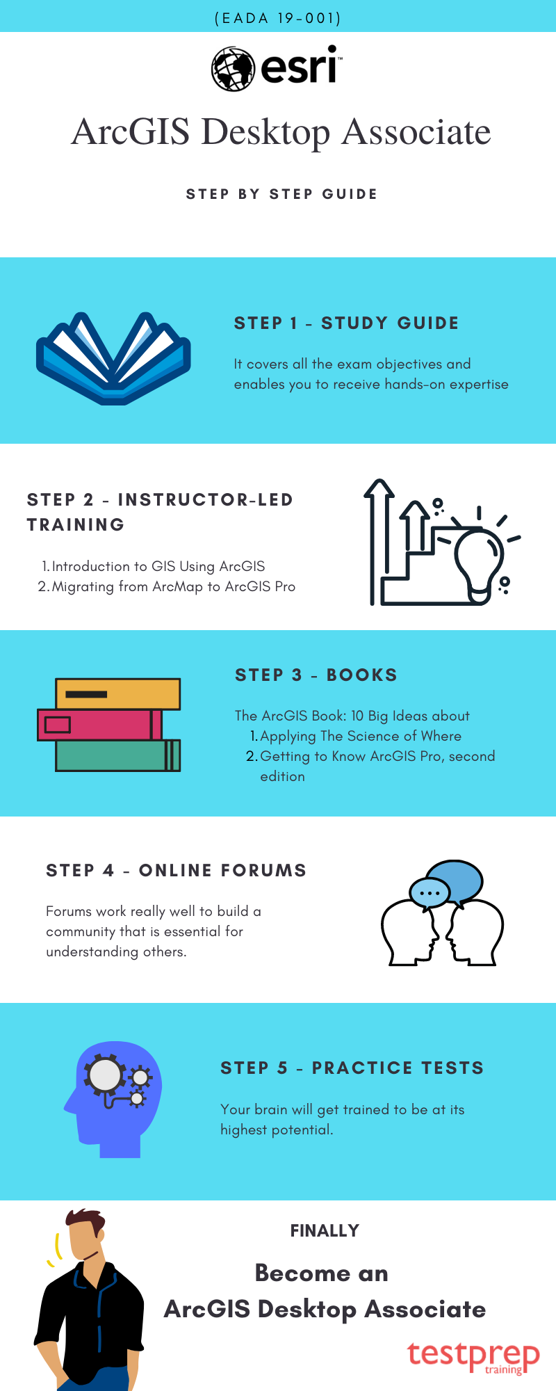
Step 2- Instructor-led Training for ArcGIS Desktop Associate Exam
The Esri Academy has designed two instructor-led training programs for the ones seeking to take the ArcGIS Desktop Associate 19-001 Exam. These instructor-led training aims to enhance the knowledge of candidates in the ArcGIS platform, enabling them to get familiar with their roles as an ArcGIS Desktop Associate.
1- Introduction to GIS Using ArcGIS
The Introduction to GIS Using ArcGIS training program will train you in the fundamental concepts underlying the GIS technology and geographic data. With this training candidates will attain experience in using GIS maps in visualizing and exploring real-world features. You will also gain knowledge in analyzing data in answering questions and creating new information, and also sharing maps, data, and other resources for there access throughout your organization.
Goals of this Instructor-led Training
- Firstly, Identifying appropriate data in supporting a mapping project
- Secondly, Creating maps, adding data to it, and symbolizing map features to support the map’s purpose
- Thirdly, Sharing data, maps, and other content to an organizational portal
- Also, Performing spatial analysis in obtaining information about map features within an area of interest
2 – Migrating from ArcMap to ArcGIS Pro
The Migrating from ArcMap to ArcGIS Pro training includes the use of faster tools and integrated 2D and 3D capabilities, in streamlining your GIS projects, using ArcGIS Pro. This course trains you to become an experienced ArcMap user. You’ll become familiar with important ArcGIS Pro terms and ideas. Plus, you’ll be able to effectively do various tasks connected to mapping, editing, analyzing, and sharing geographic information and tools.
Goals of this Instructor-led Training
- To begin with, creating an ArcGIS Pro project and importing map documents and 3D scenes
- Then, creating and modifying map symbology and layouts
- Subsequently, importing a Geoprocessing model and identifying potential migration issues
- Also, sharing Geospatial resources to an ArcGIS Online organizational site or on-premises ArcGIS portal
Step 3- Traditional way through Books

The Esri Academy offers recommended books that can be useful for your exam preparation. These books contain valuable resources to help you understand the exam objectives better, pass the test, and earn your certification. The two important books recommended by the Esri Academy for the exam are:
- The ArcGIS Book: 10 Big Ideas about Applying The Science of Where
- Getting to Know ArcGIS Pro, second edition
Step 4- Join Online Forums
Engaging in productive discussions is helpful, whether it happens in person or online. Online discussion forums offer students a great opportunity to talk about their challenges and learn from how others are preparing for exams. The advantage of online platforms is that they can attract a larger audience compared to offline discussions, which are limited to a smaller group of people. When more people participate, there’s a higher chance of finding solutions to problems and gaining valuable insights.
Furthermore, having different perspectives adds variety and richness to the discussions. These conversations enhance the depth of learning. Even individuals who are typically reserved can share their thoughts, as online forums provide a platform that’s comfortable for them. Forums are effective in creating a community that’s vital for gaining insights from others and building mutual understanding.
Step 5- Practice Tests
Mistakes are bound to happen, but they can certainly be minimized. When it comes to exams, practicing with sample papers plays a significant role in reducing errors. This is because mistakes made while practicing can be corrected before the actual exam. Training your mind is crucial. ESRI Desktop Associate 19-001 practice exams provide a simulation that helps your brain get accustomed to the real exam conditions.
Besides knowledge, there are various factors that can impact your performance during the exam. These factors include confidence, speed, understanding how the scoring works, staying mentally and physically alert, concentration, and more. Furthermore, ESRI Desktop Associate 19-001 practice exams assist in improving these aspects.
The better your performance in practice exams, the more confident you’ll become for the actual test. You’ll also gain a clear understanding of where to focus your time and effort on different sections of the exam. Your brain will become better at performing at its highest capacity during the actual test. These factors can significantly impact your results. Keep in mind that your score doesn’t solely reflect your knowledge but also how effectively you express it. Talent can only be evaluated when it’s demonstrated effectively in your performance. Start Practising Now!